Winter Storms (1 of 2)
3.9 um imagery aids in the interpretation of complex cloud patterns. Those images,
in combination with other GOES image channels, provide valuable information for
satellite monitoring and analysis of the evolution of winter storms. A daytime 3.9
um image loop, from 1515 to 1945 UTC on January 7, 1996, shows the major winter
storm which has been referred to in the media as "the blizzard of 96." This storm
produced snowfall totals of 12-30 inches over a large region from Kentucky to New
England and had a major impact on the millions of people in the region's largest
metropolitan areas.
In the 3.9 um reflectivity image loop below (see the Day-time
Reflectivity discussion), the darker shades are
areas of low, outgoing radiative energy and the brighter shades are the higher, outgoing
energy. The darker cloud areas indicate cloud tops composed predominately of ice
particles, while the brighter areas show clouds consisting mainly of water droplets.
The storm's cloud shield is made up of smaller cloud regimes, each taking on its own
unique appearance (or grey shade) in these reflectivity images. (Multi-channel
comparison imagery of this storm is presented on the next "page").
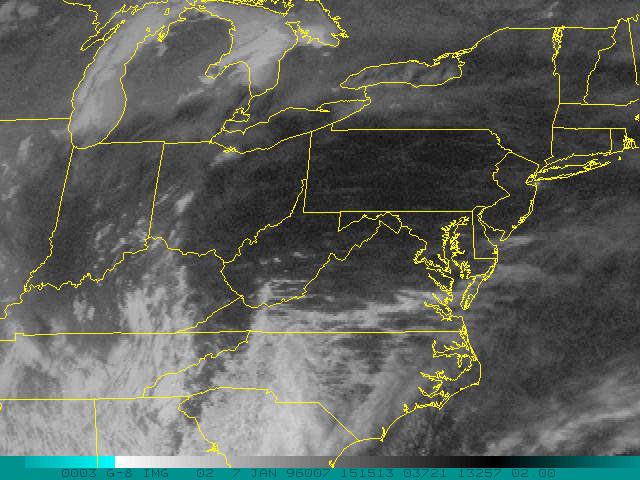
Click on the image above to download the associated loop images.
A more in-depth discussion of this storm and its corresponding satellite imagery
interpretation follows:
- A band of cirrus aligned along the jet axis is streaming to the northeast over the Atlantic,
along the NC coastline. A broad, rather uniform, deep stratiform cloud layer is moving
northward across PA and NY. A comma shaped cold cloud area is evident over WV and
OH, with a "tail" extending into NC. To the east of the "tail" feature, relatively deep stratiform
cloud is moving to the northeast across VA and NC. This cloud regime appears brighter in
the 3.9 um imagery due to the presence of supercooled cloud water at cloud top. Another
cloud area appears to the west of the "tail" feature, which also consists of water cloud, but
has somewhat of a different appearance and shows motion directly to the east. Finally, a
patchy cloud regime, which consists of cloud-tops with both ice and water, can clearly be
seen circulating around the mid-level low pressure center in south central KY. Lake effect
cloud bands associated with Lakes Michigan and Huron consist of water clouds and are
located in the otherwise clear region to the north and northwest of the storm.
Note that the boundaries between the cloud regimes are fairly sharp in contrast with the
smoother transition one would likely observe by overlaying contour analysis fields of
geopotential height, temperature, vorticity, etc. It is likely that the changes which occur as
a cloud regime boundary moves across a station are quite abrupt and that the cloud
information, when used along with representative radiosonde observations, can be used to
refine the conventional analysis fields.
Continue or go back to the Image Applications summary page.