|
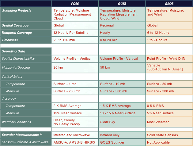
The coverage of observations over the earth is a function of both satellite orbit track and radiometer scanning geometry. Viewing geometry determines the earth viewing capabilities and limitations of the satellite radiometers. |
|
Sounding products define the baseline products for each observing system. Please refer to the POES Product Comparisons Table for more complete product descriptions and availability information. |
|
Temporal coverage refers to the frequency of observations at a given point on the earth. |
|
Timeliness refers to the delay between the observation time and when products are available to the user. |
|
Satellite sounding data consists of derived atmospheric temperature and water vapor mixing ratio profiles. Products are defined at a given latitude, longitude, and pressure level. The products are generated based on the atmospheric sounder radiometric measurements. Specific characteristics of POES, GOES, and RAOB sounding products are described below. |
|
This defines the horizontal and vertical characteristics of the derived sounding profiles. |
|
Horizontal spacing refers to the average distance between the centers of two adjacent soundings. |
|
Vertical extent refers to both the top and bottom limits of sounding data as well as the average vertical resolution. |
|
Collocated RAOBs provide temperature and moisture accuracy measurements for large samples of POES and GOES sounding data. |
|
This section refers to weather conditions that affect the availability of sounding measurements and products. |
|
NOAA polar orbiting and geostationary satellites are equipped with radiometric sounders. GOES contains an infrared sounder, while POES deploys both infrared and microwave sounders. Sounding instruments provide radiation measurements sensitive to the vertical distribution of atmospheric temperature and water vapor. |
|
This section maps out the sounder instrument sensor suites by spectral region and sensitivity to atmospheric temperature and moisture. Clicking the "POES" and "GOES" cells reveals sounder instrument details such as the number of channels and their horizontal and vertical resolution. |