
Return to the previous menu.
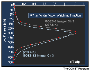
The graph on the right compares the weighting function for the spectrally widened GOES-12 water vapor channel with that from GOES-8 in a standard atmosphere. Recall that the area to the left of each curve represents the vertical distribution of detected energy, in this case infrared emission from atmospheric water vapor in the middle to upper troposphere.
Most of the energy detected still originates from water vapor in a layer that extends from 500 to 200 millibars.
Note however, that the GOES-12 water vapor channel weighting function peaks slightly lower and covers a slightly deeper atmospheric layer. The result is that the satellite will observe upwelling radiation and water vapor signatures originating somewhat deeper in the troposphere.
Next | Previous | Main Menu | Page: 1 | 2 | 3 | 4 | 5 | 6 | 7 | 8 | 9 | 10 | 11 | 12 | 13 | 14 | 15 | 16 | 17