
Return to the previous menu.
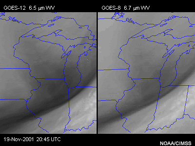
The GOES-12 6.5 micron water vapor detector scans at an improved resolution of 4 km at the satellite sub-point, compared with 8 km for GOES-8 to -11. An oversampling of the 4 km field-of-views in the east-west direction by a factor of 1.75 provides an effective east-west resolution of 2.3 km.
This first comparison between GOES-12 and GOES-8 water vapor imagery demonstrates the improved resolution with GOES-12. Notice that the water vapor boundary associated with an upper-level jet streak is enhanced and appears smoother than with GOES-8.
This example of a November Central Plains cyclone highlights how higher resolution water vapor imagery can aid in the analysis of smaller scale features and associated mesoscale forcing mechanisms, such as the interactions between mesoscale jets and wintertime precipitation.
Notice that the GOES-12 imagery (top) more clearly depicts two separate jet streaks to the east of the deepening cyclone. Animation shows the development of heavy snow bands oriented east-west and to the north of the western mesoscale jet streak. The higher resolution GOES-12 imagery also makes it more evident that both jet streaks are intensifying (as seen by the darkening/warming) over the course of the animation.
Next | Previous | Main Menu | Page: 1 | 2 | 3 | 4 | 5 | 6 | 7 | 8 | 9 | 10 | 11 | 12 | 13 | 14 | 15 | 16 | 17